Satellite imagery and machine learning have provided a groundbreaking new view of the maritime industry, specifically in regards to fishing and transport ships at sea. This technology reveals that there are significantly more vessels than previously thought, a fact that policymakers should take into account.
The oceans are a shared global resource, and yet different countries and regions have their own unique customs, laws, and motivations. While the automated identification system (AIS) is becoming more widely used and tracks ships through their onboard transponders, it is not universally applied. As a result, crucial data such as the number of vessels fishing in an area, their operators, and the amount of fish they are harvesting remain unclear, pieced together from local, proprietary, and government-approved sources.
This lack of comprehensive information not only makes policy decisions difficult and approximate, but also creates a sense of lawlessness in the industry. Many ships clandestinely enter restricted or protected waters, or exceed safe harvesting numbers for rapidly depleting fish stocks.
However, satellite imagery offers a new solution to this conundrum: a bird’s-eye view that can’t be hidden from. The sheer scale of the maritime industry and the imagery documenting it is immense, but fortunately, machine learning technology is capable of accurately tracking tens of thousands of ships at sea at any given moment.
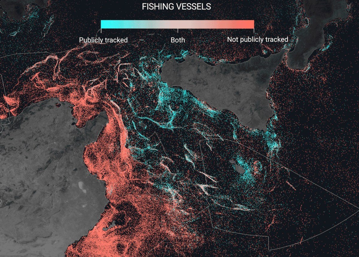
“Not publicly tracked” doesn’t necessarily mean completely unaccounted for.
“There are a few reasons why these vessels are missing from public tracking systems,” explains Fernando Paolo, lead author of a paper published in Nature. “Some vessels deliberately turn off their transponders or operate in areas with little or no satellite coverage or AIS infrastructure. Additionally, some countries have their own proprietary systems for tracking vessels within their own waters, but this information is not shared with other nations.”
As the global population grows and the oceans warm, it is increasingly important for data like this to be shared beyond national borders and internal agencies.
“Fish are a dynamic resource that move around, so openly tracking fishing vessels is crucial for monitoring fish stocks,” says Paolo. “Without all vessels publicly broadcasting their positions and activity, it is difficult to understand and map the full ecological impact of these ships.”
Visualizations show that Iceland and the Nordics have high levels of tracking, while Southeast Asia has the lowest, with practically zero tracking off the coast of Bangladesh, India, and Myanmar.
However, as previously mentioned, this does not necessarily mean that these vessels are all operating illegally. It simply means that their activity is not shared, as required by law in the Nordics. But with the new satellite data, it has been discovered that the Asian fishing industry is vastly under-represented.
If you were to only consider AIS data, you would think that 36% of fishing activity occurs in European waters, and 44% in Asia. However, the satellite data contradicts this, showing that only 10% of fishing vessels are found in European waters, while a staggering 71% are located in Asian waters. In fact, China alone appears to account for 30% of all fishing activity worldwide!
This is not meant to place blame on any specific country or region, but rather to bring attention to the fact that our understanding of the scale of the global fishing industry is inaccurate. Without reliable information, our policies and scientific research will be fundamentally flawed.
On a concerning note, the satellite analysis also revealed a regular presence of fishing boats in protected areas, such as the Galapagos islands, which is strictly forbidden by international law. These “dark” vessels have now been brought into the spotlight for further investigation.
“The next step is to work with authorities in different regions to assess these new maps,” says Paolo. “It is likely that we have identified fishing activity within marine protected areas or restricted areas that will require further investigation and protection.”
He hopes that improved data will help guide policy decisions, but the gathering and analysis process is far from complete.
“This is only the first version of our open data platform,” he continues. “We are constantly processing new radar imagery from the Sentinel-1 satellite and accurately identifying activity around the globe. This data can be viewed and accessed on our website, globalfishingwatch.org, and is updated up to three days ago.”
The nonprofit organization behind this research, Global Fishing Watch, is supported by various philanthropies and individuals, which can be found listed on their website.